Day 58: July 13, 2023 Hikers Welcome to Mount Moosilauke & The Notch Hostel Elevation+4591’/-3105’ 9.9 Miles/748.0; 1808.8

Up early this morning to get a jump on Mount Moosilauke. Mary Poppins, Blue and I were out the door just after 6am. As soon as we reached the trailhead, there was a river crossing. We decided ahead of time that we would take off our shoes and try, if at all possible, to keep our feet dry today. We walked barefoot in shin high water and redressed our feet. Then we were off to climb Mount Moosilauke.

1800 Mile Marker on AT. I’m closer to 1500 but closing in on 2196.4

The trail was well maintained as it’s one of the biggest highlights on the Appalachian. This iconic mountain is the southern entrance to the infamous Whites, aka The Presidential’s. I knew it was going to be a climb so I went about it slow and steady. If I paced myself going up, then my legs would serve me well on the way down. We had three hikers pass us, which I wasn’t surprised by. The young boys have much more energy than I do and I wasn’t racing anyone. The weather was cool and crisp. No humidity and no rain. I couldn’t have asked for anything more.

The Many Thousands of Boulders We Hiked Over Today

Blue was my tail and she followed me all the way to the Ridgeline. Once we arrived to the South Peak of Moosilauke, we were walking in the clouds. We both put on our rain jackets and hiked to the summit. The Ridgeline was surprisingly flat with short conifer’s and beautiful tiny white flowers that lined the pathway. Once we started climbing to the North Summit, the trail was marked with huge rock cairns, that were placed to keep hikers orientated to the trail. The wind was blowing and it was chilly. But still no rain. Praise the Lord!

Ridgeline Atop Mount Moosilauke

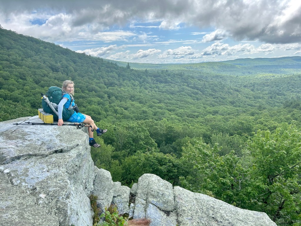
We reach the wide, open summit of Mount Moosilauke, one of the highest peaks in New Hampshire, and the first 4000-foot peak that northbound AT hikers climb since Virginia (not counting Killington in Vermont, accessed by side trail). I’m sure the views were spectacular from atop this beast but that wasn’t accessible to any hikers today. Blue and I took the customary photo at the peak, found a rock wall to hide behind and ate lunch.

Mount Moosilauke Summit 4802’

The route down was stunning. It followed more conifer forests with many ferns, leaved plants with teeny tiny white flowers that hugged the rock garden and overhanging foliage. It was like walking through an enchanted forests, just no fairies or dwarfs, that I saw. We had a few vista’s that started to open up to the forested mountains beyond.

The Conifer Forest

Once we dropped elevation, the fun began. Blue led the way down the rock boulders that followed a cascading waterfall for a couple of miles. My knees were doing good and my ankles were holding up, but my feet slipped on some of the mossy rocks. I took one slip that landed me on my butt, jammed my already not-so-perfect right shoulder. Nothing broke, and within a minute of checking myself, I was back at it to finish the final mile or so. Not too bad for a steep ascent and descent, if I say so myself.

Beaver Brook Falls

Notch Hostel had a predetermined pick-up time at 4:30pm. Blue and I arrived just after 2pm so we had sometime to waste. We ate the rest of our goody bags and by 3pm, we were ready for a ride. No one at the Hostel answered so we were left to our own recourse, hitchhiking. This is something new for Blue and honestly, not my favorite thing to do. But there was a good pullout for passing cars to stop and Blue stuck out her thumb. Within a few minutes, a pickup truck pulled over. It was a couple of local guys who were getting off work. After telling them where we were headed, they were happy to give us a ride. Blue and I did another first, and hopped in the bed of the truck, with beers that the nice men provided. The wind was blowing in our face and for the first time today, I was going faster than a mile an hour!

Girls Gone Wild in Truck-bed

They pulled into our luxury accommodations at The Notch Hostel. Blue and I scored the best room on the property, a private suite with our own bathroom and coffee maker with refrigerator. This is living. I caught up on my emails, texts and called my favorite daughter Cherisa. She is my one and only daughter, but definitely my favorite. We talked on the phone for close to an hour. My daughter is an amazing mother of my grandson Quin, and has taught him the ways of the Lord. I always marvel how God our Father has blessed me with such goodness. This was all I truly needed after a day of climbing Moosilauke.

Me & My Favorite Daughter

Day 57: July 12, 2023 Mount Cube to Hikers Welcome Hostel Elevation+4290’/-2472’ 13.2 Miles/738.1; 1799.5

Cowboy camping is something everyone should do at least once on trail. This is my second time this year and I never regret it. The weather was perfect and the sky did not disappoint. There was a sliver of a moon, which I never saw as it was hiding low on the horizon. But what I did see was the numerous stars that our mighty God knows by name, and the Milky Way stretching across the sky. There was no ambient light shining from any nearby town or city so the sky was the theater. It was glorious. And the sunrise was pretty nice too!

Sunrise from Mount Cube

It was a fast pack up with no tent and only good coffee this morning. We saw three northbound hikers before 6am, and we were right behind them. The morning walk was nice with a slight downhill to Brackett Brook. Two days ago, hikers that forged this Brook had water to their waists. Blue, Mary Poppins and I had knee deep water and we were grateful. What a difference it makes when the rain stops for a couple of days. The flow was much less and easily crossed.

New Orange Mushroom

We started our climb to Mt. Mist. It was fairly easy with some Beaver Bogs along the way and more moose droppings. We saw lots of frogs hopping around, and a few birds chirping.The mushrooms are growing so big these days and quite colorful. The ones I’ve been seeing are in the warm spectrum from yellows to oranges and reds. They really pop out in the midst of the brown and tan colored leaves and the dark mud.

Camouflaged Frog

Mary Poppins bounced ahead and was leading the climb. She, like us, was ready to get our milage done and head into town early. Blue and I mosied along and talk to several southbound hikers. Most of the Sobo’s as we call them, left Maine the first of June or mid-June. We are starting to see 2-4 per day and I’m sure they will see 10-15 Nobo’s a day. We definitely outnumber them. It’s great to chat and get intel of the trail ahead. Todays talk was mostly surrounded Mount Moosilauke which is our goal tomorrow.

First Sighting of a Moose

We ran into Mary Poppins sitting under the “You Almost Missed Mt. Mist” trail sign. Mt. Mist was an unremarkable peak with many trees and no vistas. I definitely would’ve walked right past it. We were looking for a place to make a call in hopes to reserve a room at The Notch Hostel tomorrow night. We found a spur trail which led us to a slight opening. Mary Poppins had service and confirmed beds for the three of us.

Mary Poppins at Mount Mist

Once off the phone, we hiked the last two miles which seems like ten! I don’t get how the final mile or two drag on forever. It was mostly downhill, through rocks, creeks and yep, more mud. We finally arrived at the road, and walked to Hikers Welcome Hostel.

Hikers Welcome Hostel

This is one rustic place that could use some TLC. But they provide bunk beds, showers and laundry. Yes, we will take it all. The shower and laundry was outside along with the toilet. They cater to the No-frills hikers who are looking for something cheap and close to trail. There were 15 or so hikers there. Us girls all showered and I used loaner clothes so I could wash all my personal clothing. It works well. Most places have excess clothes that you can wear while your one or two outfits are being washed.

Outdoor Shower, Laundry & Toliet

They provided a shuttle to town of Warren, which really isn’t a town. It’s a convenient store with sandwiches, pizza and gas station food. Blue and I ordered a Greek Flatbed Pizza and picked up a few things to hold over till we get our resupply tomorrow.

Our Bunkhouse

We were back at the Hostel by 6pm, ate pizza, drank beer and I headed back to my bunk to prepare for tomorrow’s day. Blue talked with Mimi for a bit about life. The Hostel provided slackpacking so we are taking advantage of that opportunity. We will continue northbound and the Hostel owners will take our packs forward to The Notch Hostel, our next destination. This is absolutely wonderful!

Blue at Hikers Welcome Hostel

After packing my daypack, I crawled in my bunk and prayed. Tomorrow is our first introduction to The Whites. We have Mount Moosilauke which is an intense up and down, but without a pack, I’m hoping I can get it done quicker. Our Lord is bigger than these mountains and He has big plans for us. Thank you Jesus for giving me strength, courage and wisdom to do what you have designed me for. I so love your path, whatever it may bring. Keep us from peril and watch over the weather as we head north.

Day 56: July 11, 2023 Lyme to Mount Cube Elevation+4290’/-2472’ 13.1 Miles/711.9; 1786.3

What a difference a day makes! After yesterdays downpour, this morning I woke up to birds singing and blue skies above. Oh how lovely a day it will be. Dowd’s Country Inn makes a full made to order breakfast for hungry hikers. I had a mushroom omelette with bacon, potatoes and toast with grapefruit juice please. It was exactly what I needed. Mary Poppins had the same and Blue had her Sunny-side up eggs with all the fixings. We were fueled for the outrageous climbing the AT had planned for today.

Dowd’s Country Inn Lyme, NH

Darrell gave us a ride back to the trail and we were in formation by 8:45am. A bit late for us but nevertheless, we were ready. The trail was, let’s say wet. With the constant rain from the past days, there is nothing dry underfoot. From our first step on the trail, we were submerged in mud and muck. The positive thing was within a hundred yards or so, we had a river crossing. At this point, I’m convinced that this is only the first of many river crossings so I’m going in. No trying to skip across rocks, or going up and down stream trying to find a log crossing, I just walked across. Blue and Mary Poppins did the same.

Number One River Forging

We had flowing water on the trail for most of the morning. There was just too much water and the ground can’t absorb it anymore. The trail is the path of least resistance so that’s where the water drains. It makes perfect sense. The morning was gorgeous. The temperature couldn’t had been better, not too hot and not too cold. It wasn’t even humid which I thought it would be.

First Meadow and Pond Along the Trail

After climbing for a bit, we made it to Lamberts Ledge. It was reached by walking atop of series of granite rocks that were polished and smooth. After hiking for more than an hour or so, we made it to a great vista and with the clear skies, we could see Dartmouth Ski Hill and the Town of Lyme. We sat and had some snacks. Yes, that is pretty much what we do all day. Hike and eat!

Blue on Lamberts Ledge

After our break, the next big climb was reaching the summit of Smarts Mountain, the highest peak in the region and site of a fire lookout tower. Views from the Smarts Mountain Tower are some of the most outstanding on this section of the AT. The taller peaks of the White Mountains were clearly visible to the northeast, while other central New Hampshire peaks like Cardigan and Kearsarge are seen to the southeast. Plus the high peaks of Vermont were clear, and I could see the Connecticut River to the west, that I crossed three days ago. It was outstanding.

Inside Fire Tower with Views Everywhere

An old fire warden’s cabin is located at the base of the fire tower, and is maintained as an Appalachian Trail shelter. The cabin has space for about 8 people. It’s a bit rundown but I’m sure there were many hikers holding up in it yesterday with all the rain.

Smarts Mountain Fire Tower

After checking out the sights, we moved along and headed down the mountain and went back to the wet and muddy trail. We had several River or Brook crossings today and all but one, we submerged our feet directly into the water. There was no denying the amount of water that has accumulated from our storms. There has been talk on the trail that one of the upcoming rivers was impassable yesterday with hikers having to turn around. Originally we had planned to attempt crossing it today but we changed our plans.

Jacobs Creek

So today we saw a lot more hikers out and about. There was a huge group that were at the Fire Tower, close to a dozen. There was a dog named Summit that hiked with us for awhile before Summit’s owner caught up with him. Then there were a couple of guys who were backpacking barefoot. That was the first time I’ve seen that! And on our way to Mount Cube, I ran into Unhurrey B, aka Moses. Moses stopped and we talked for a bit and then he asked me, are you Kelly? Yes, I am. How do I know you? He’s been following my blog and Facebook posts for the past two years. He’s hiking the AT Southbound this year so our paths just happened to cross. Such a small and wonderful world!

Moses with Me & Blue

After climbing close to 4300’ today, I made the command decision to camp atop Cube Mountain. We had plenty of water, imagine that and the weather was perfect. Not a cloud in the sky and the forecast is for no rain till tomorrow afternoon. We have a perfect window of weather and this may be our one and only chance to cowboy camp. Blue and Mary Poppins were thrilled to stop but chose the confines of their tents. Norman and I are sleeping outside, under the stars and loving our little paradise on the rock. Honestly, this is the best campsite I’ve had in quite sometime. What an ending to the most perfect day! Norman agrees. His animal tendencies are being magnified while he is sleeping outside. He is one happy camper!

Norman & I Cowboy Camping on Mount Cube

Day 55: July 10, 2023 Hanover-Etna to Lyme Elevation+3598’/-3485’ 13.8 Miles/698.8; 1773.5

The rain never stopped last night. I am so grateful for “The Tank”. This was the name for our home for the night. A Class C Motorhome that has been permanently parked at Ralph & Karen’s home. I can only imagine how many hikers have slept in this rig. The stories it could tell!

Ralph, Our Trail Angel & Owner of The Tank

Blue and I headed into the house, had breakfast of coffee and more coffee. I was looking at the weather. Nothing but rain. Is this ever going to stop? Well, not today. Ends up I received a weather alert from the ATC, Appalachian Trail Conservancy that the trail has been washed out and closed in several areas south of us. Bear Mountain in NY and Southern Vermont are impassable. Hmm, didn’t mention New Hampshire so I think we are clear to go. We packed up our bags and Ralph gave us a ride to the trail.

Hello New Hampshire

The Warning from the ATC: A state of emergency has been declared in Vermont due to flash flooding and flood watches/warnings are in effect for counties along the Appalachian Trail (A.T.) in New York, Connecticut, Massachusetts, New Hampshire, and southern Maine. Several roads have been closed in southern Vermont which may affect access to the A.T. The heavy rain may cause flooding.

That’s Our Forecast – Lovely

The trail was wet, flowing with lots of water and besides Blue and I, we didn’t see another soul. We headed north towards Moose Peak. The terrain was typical, ups and more ups with forests, ferns and lots of green foliage. The mushrooms are loving this wet environment and I saw so many along the way.

Mushroom the Size of my Face

As we headed up to Moose Mountain, we passed a couple of low lying flood plains. No wonder it’s called Moose Mountain because this is prime territory for these majestic creatures. Once again, Blue and I saw nothing, nada, zilch. I don’t know if they’re hiding out because of the rain or just hiding out? We continued up the mountain until we reached Moose Mountain Shelter.

Love These Pictograms

When it rains, or downpours, there’s really no place to stop to eat, unless you can find a Shelter close to the trail. Lucky for us, Moose Shelter was only .1 miles from the trail. We hiked in and met Physics. He’s a thru-hiker who started back in Georgia on March 15th. He was buying time as his wife was driving from South Carolina to spend a couple of days with him. He also needed some cold-weather gear for “The Whites.” Blue and I ate some snacks and proceeded north. Physics was right behind.

North Moose Mountain

Within a few minutes, we made it to the peak, and it was a downhill slide, literally, as we made our way down to the gully. The rain was still pounding us and the dirt, mud, leaves and rocks were slick as snot. Somehow, someway, Blue and I maintained, somewhat, perfect balance. Well at least we never landed on our bottoms.

Rivers Were Rushing

Once down to the road, we had one more climb for the day. It started out fairly flat, then a boardwalk that was overflowing with water from the last 24 hours of deluge! We passed Beaver Pond that was more like a Bog, completely soaked our shoes and socks and started our final climb up to Holt’s Ledge. It was a bit steeper than Moose Mountain. No, it was a lot steeper! For the first time this year, I had my rain jacket and umbrella in use. The rain jacket isn’t such a bad thing but the umbrella really blocks my vision.

Bog on our Way to the Ledges

The trail was a river and hard to tell what was a trail and where I was suppose to get my drinking water from. At one point, I pushed my umbrella to the side because it was a raging river coming down the mountain. I checked my FarOut App to make sure I hadn’t missed a turn. It confirmed that I was directly atop the trail, that just so happened to be a torrent of water. That’s just perfect!

River or Trail?

Blue and I made it to the ledges and the rain finally subsided. The views were still obscured but at least my umbrella wasn’t the reason I couldn’t see anything. I could only imagine what I may have seen. Yet, I was as happy as a clam that I have a trail to navigate, and a hiking partner that is crazy as me. What an adventure we have had.

Overlook from Holt’s Ledge

The rest of the afternoon was a slog heading down. We saw one other hiker heading up as we were finishing up our day. He must’ve waited till the rain stopped, trying to get in a few miles during a break in the storm. As we arrived to our destination, Mary Poppins caught up with us. She hiked an additional five miles, never stopped and made it virtually the same time as Blue and I. That woman ceases to amaze me.

Mary Poppins and Our Packs

Darrell picked us up and drove us to The Dowd’s Country Inn in Lyme, NH. It’s an restored Bed and Breakfast that caters to all sorts of guests. Today they had 10-15 wet hikers who were looking for shelter from the rain. I’m thinking this rain has got to stop sooner or later! From what the locals are saying, they have never had such a wet and rainy year. Just my luck!

The Dowd’s Country Inn

The three of us walked, in the rain, walked to the Country Store and purchased some items to make dinner. Charcuterie Board it is. Meats, cheeses, crackers, fruit and salad. Much better than any dehydrated meal I have in my pack. We had hot tea, chocolate and a proper table to sit at. It just doesn’t get any better than this.

Lyme’s Country Store- The One & Only

Today, we had some choices to make. Should we stay or should we go? Did we want to hike long miles or do what we could to get closer to Maine? Blue and I chose to get on the trail, and hike as far as we could. Even with the pouring rain, we still laughed, stayed positive and somehow someway, made it to our next destination, Lyme. This sets us up for two more days before we start our serious business of climbing Moosilauke, our first big obstacle before entering The Whites. All that we have done in the past week or so, is preparing us to tackle what is to come. With God’s good graces, we are continuing north, ever so carefully and thoughtfully.

Day 54: July 9, 2023 West Hanover to Hanover, NH Elevation+2041’/-2311’ 14.8 Miles/680.0; 1761.9

It was a lazy morning. I crawled out of the confines of my little home around 7am. It wasn’t raining but just a dreary day. Linda had coffee and hard boiled eggs along with fruit and miscellaneous foods for hikers on her porch. I sat and drank coffee with her, and talked for sometime. She has 8-10 hens who lay many eggs, and one rooster who likes to wake up hikers early in the morning. It appears to work being everyone was packed up and out by 7:30-8:00am. Good plan Linda. Move along hikers.

Yellow Shroom

As Blue and I headed out of town, we walked along the road for a bit. We met the owner of the original schoolhouse built in the 1800’s. The gentleman told us he bought it when he returned from Vietnam in 1960’s for $17,000. He has restored the schoolhouse and has lived there for over 60 years. Vermonter’s strike again. Such an honor to hear his story and love for this village, as they call it.

Welcoming Homes Along the Trail

As we headed around the corner, the trail appeared and we were back on our ribbon of dirt. Today was easy ups and downs, with little mud and plenty of water in the rivers. There was nothing lacking except for my energy. I have some days where I’m full of energy and then days like today, that I just can’t seem to get out of low gear. Thank goodness, it was easy terrain. With that being said, I still stopped for a couple of breaks trying to refuel with mango strips, beef sticks and anything I could find in my food bag. No real success there.

Norman and I are Taking a Nap

Mary Poppins was waiting for us in Hanover, New Hampshire. We just needed to get to her. Around noon we walked out of the forest and started our road walk. Norwich, Vermont was our last sight in this state. It was a great way to end our journey in the muddy, rainy, humid but beautiful state that I learned to love.

See ya Vermont – IHello New Hampshire

Heading across the Connecticut River, we entered the second to the last state of the Appalachian Trail, New Hampshire. The river looked more like a peaceful lake and reminded me of Lake Natomas in Folsom, close to where I live. There were kayakers skimming across the river as we passed. Such a grand entrance to Hanover, the home of Dartmouth University.

Connecticut River

Once in Hanover, it is obvious that this city is all about its Ivy League School. Everywhere you look, its’ Dartmouth. Parents are buying shirts for their toddlers and taking pictures in front of the school. We visited the Dartmouth U Retail Store to find out what this school was all about. Ends up it’s the premier Medical School, along with Business, Engineering and Master Programs. Did I ever feel like an uniformed hiker!

The Educator of all Things Dartmouth

Mary Poppins had a booth for us at Lou’s Cafe. She had already eaten and Blue and I waltzed in and sat with her. Ends up that the place was not taking any more patrons as it was getting close to closing time. Blue and I lucked out because our waitress was quite accommodating and took our order lickety split. Blue had a Chicken Pesto Salad and I had Butternut Squash Salad, that was over the top. Endless cups of Iced Tea and a free donut for hiking the AT. This is my kind of place.

Officially in New Hampshire

After lunch, we dropped off our packs at one of the halls of Dartmouth. They allowed thru-hikers to use this building to rest, recharge devices and free locker storage. We saw a few other hikers, sorting through their resupplies, chilling on the couches and dropping off gear. We stashed our packs and hit the town. It’s a College Town with tons of eateries, coffee shops and clothing stores. We headed to the Coop-Market for fresh fruits, vegetables and chocolate. It was a high-end store with expensive prices but we’ve learned that the farther north in New England we go, the pricier it gets. This was no exception. But, we needed some fresh food and are willing to pay whatever it costs. Good thing, we are only buying for ourselves and not a starving student! We sat outside on a bench and ate some produce, chocolate and MaryPoppins had her quart of Gelato. She needs the calories as she’s been hiking since Georgia. We finished our goodies and returned to retrieve our worldly possessions.

Mary Poppins Taking a Nap at Dartmouth Hall

Blue and Mary Poppins made reservations with Ralph to stay in Etna in his trailer for the evening. Perfect! Out of the rain and access to a shower and laundry. When you have one outfit you wear daily, doing laundry often is key to reducing the stench of foul odors. Ralph met us in the afternoon and gave us a tour of his lovely home in the woods. We were so blessed to be out of the rain, pampered in a nice home, and surrounded by a caring family. Thank you Lord for leading us to this place, and providing a wonderful and safe home for the night. Amen.

Day 53: July 8, 2023 VT-12 to West Hanover Elevation+3344’/-4077’ 14.6 Miles/665.2; 1746.3

What a lovely breakfast we had this morning. I can’t say I ever eaten Breakfast Tacos, so this was a first. There were scrambled eggs, green tomatoes, green salsa, cheese and cilantro. The Chef made muffins with green tomatoes and cheese. It was scrumptious. We all piled into the Van and Mosie drove us back to the trail by 9am.

Mary Poppins, Blue, Me, Speedo, Flipper & Lizard

Blue and I took off with Mary Poppins but she is a bit faster than us. We told her we’d meet up for lunch at the River Crossing. The morning was perfect for a good climb. The ground was moist but not too muddy from yesterday and last nights rain. We had a grassy knoll that had views of the Vermont Farms, where Blue and I considered hiking yesterday. I’m glad we stayed in the Treehouse and Norman thoroughly enjoyed his stay!

Flipper Admiring the Meadow

About five miles up and over, we arrived to Barnard Brook. There was a cable that was strung across the river, giving hikers something to hold on to as they cross the river. I waded with my shoes on and it was shin deep. Blue headed up the creek, not wanting to get her shoes wet, and was able to stay a bit drier. We stopped and had lunch with Mary Poppins, and talked about the rest of our days hike.

George Lookalike Riding His E-Bike

There was a lot of climbing today and the only thing I can think about, is this is our preparation for what’s to come. Besides it being hot and humid, we had no rain for most of the day. Vermont is getting prettier the farther north we get. Today we went through forests and then we’d open up to fields of grass with wildflowers everywhere. There were quite a few private property’s that we skirted with signs asking hikers to adhere to the trail. It was a picturesque day indeed.

Hikers from Sweden

Around 2pm, I found our first raspberry field of the day. The first patch was smaller but the further north we went today, we had fields of raspberries. Blue and I needed buckets to collect as many as possible, but we also needed to get some miles completed. We ate and walked, ate more berries and walked a bit more. Such a great snack after lunch of Beef Jerky and Potato Chips.

Raspberries Everywhere

Today was a gorgeous day and truly showed the diverse nature of this region. The tall lodge pines reached the sky. Some were 250-300’ high, then there were alders that were older than Moses, with field of grasses filled with ticks, not so good. Each time we exited the grasses, Blue and I would search for ticks. We found a few and would squash them and move along.

Tall Trees

Around 4pm, we stopped for a snack. We both were a sweaty mess and needed to replace some sodium. We found a good log to sit upon and proceeded to finish my bag of potato chips. Then we moved on to Seaweed. I’ve found that my body tells me what I need and today it required lots of sodium. It started raining, which was fine with both of us. It actually cooled us down a bit. This rain didn’t last but a few minutes. We finished our high salt intake and now up, to end our days work.

Glistening? No Sweaty Profusely

With only two miles to go, and mostly downhill, we scooted through the mostly forested area. There were a few gullies with ferns, standing water from the last couple of storms, and the earth smelled so good. I found tons of mushrooms today. Big ones, tiny ones, groups of shrooms growing on dead tress. We found a clean water source and filled up. Tap water taste terrible after days of fresh running creeks and springs.

Wildflowers Everywhere

Around 6pm, we arrived in West Hanover, which is a small town with four villages. It was hit hard by Hurricane Irene in 2011 and close to 3000 families lost their homes. Much of the area hasn’t rebuilt but the heart of the town is Linda. She has the Blue Barn and houses hikers on her property. When we arrived, there were no less than 12 tents pitched in her backyard.

The Blue Barn

Linda was in the front porch celebrating her 37th Anniversary with her husband. The three daughters and friends were there, having a great time. Linda offered us a soda and told us to pitch our tent anywhere that there was high ground. When it rains, her yard floods. Good to know. We found a high spot and went to work building our homes for the night. Afterwards Blue went to the river to cleanup and I started talking with Mary Poppins.

Overlooking Vermont

Vermont is growing on me, just as I am ready to leave. It’s diverse beauty is in the terrain, the countless ecosystems and the people I’ve met along the way. Vermonter’s as they call themselves are hardy, they have roots and typically stay for generations. Linda is third generation so she’s a local. Her Grandpa moved here from Scotland when he was three years old. Linda’s Dad is one of nine and he was the guy that repaired everyone’s tractors in the area. There is not a soul in town that doesn’t knows him! And Linda, she has remained in West Hanover and loves hikers. These are your typical Vermonters, strong, know who they are and what they stand for. They are a wonderful and inviting community of people.

Linda and Her Kitty

As I close up another state, I am so grateful for my family and friends. I’m a Californian, born and raised. I have no intentions of leaving but I love exploring other areas. Tomorrow Blue and I will be entering New Hampshire. That will be a new state, with only Maine left. Hard to believe that I have walked this far. With God’s blessing, I will be on my path for Mt. Katadrin by next month. But now, I’ll keep trekking, one step in front of the other, one day at a time.

Day 52: July 7, 2023 Stoney Brook to VT-12 Wise Pines Hostel Elevation+3018’/-3359’ 14.1 Miles/650.6; 1733.9

What a special night of restoring sleep. Sleeping next to a flowing Brook as they call them here, was so nice. I fell to sleep easily and slept through the night. Blue and I were up by 5:30am and on trail before 7am. I already saw a couple of hikers pass by using the bridge. They must have stayed at the shelter south of us.

Stoney Brook

Todays hike includes a big ascent to The Lookout Cabin. It is a privately owned piece of property that allows hikers to stay the night. We had close to six miles and 2300’ of elevation gain. The problem with the terrain around here is you go up, and then you go down. I think I’d rather just stick to the ups so you get there a bit faster, but that’s not the AT way. So the 2300’ up includes 1350’ down. That always boggles my mind. It took close to four hours as we stopped for our morning snack and filled up on water.

The Lookout Cabin

But what a place it is. The Lookout Cabin is a two-story cabin with an interior fireplace made of stone and a loft that sleeps many hikers. I imagine you could fit 20-30 weary hikers inside. It’s the nicest structure I’ve seen so far on the Appalachian. Outside is a sturdy wooden ladder that’s affixed to the side of the cabin. It stretches to the top of the roof, where there is an observation deck.

Blue Climbing to the Observation Deck

Blue and I climbed to the top and were in awe of the views we could see. In the distance, we could see to The White Mountains, some 50 plus miles north of us. We had such a clear day with magnificent views all around. It was the clearest day we have had in sometime. No smoke, no fog or rain, just endless sky. We stayed for a bit and contemplated our next destination.

“The Whites” in the Background

Blue is a Coffee connoisseur. She likes her Breve Latte and hasn’t had one since we got on trail a few days back. Ends up about five miles north is Abracadabra Coffee Company, just about 1/2 mile west of the trail. That would fuel my hiking partner and I could always use a shot of espresso too.

Inside The Lookout Cabin

We climbed down our 30 rung ladder and headed back to the trail. About a mile down, there was a fork in the road. We could continue on the AT and hope to make it to the Coffee Shop before they closed or we could take the Blue Blaze, which would land us nearer to the Cafe. Both routes were five miles, and both take us to Maine. I chose the Blue Blaze. Now the purists out there would call this blue blazing and that’s exactly correct. But I call this, get me some coffee! We made the right chose.

Blue Blaze Pond

The route went down a trail that followed Atwood Brook and many ponds along the way. It was beautiful and took us passed some beautiful homes and ranches. As for me, part of hiking any trail is getting off the beaten path, and seeing the beauty that surrounds the trail. This was no exception. I saw a WhiteTailed Deer in the woods next to us and pointed her out to Blue. We haven’t seen any large animal since she started hiking with me. Bambi turned, stuck her big tail in the air, and pranced away. Within a couple of hours, we arrive at Abracadabra. Just thirty minutes before they were scheduled to close.

Many Views Along the Way

Blue ordered her Breve Latte with a cup of Maple Ice Cream and I ordered a Cold Brew Float. I never had that before and it was fabulous. We sat outside, kicked our shoes off and savored every last sip of our specialty coffee drink. And then it rained! I figured it was just a passing thunderstorm, nothing to be concerned about. Once we finished, we donned our umbrellas and walked to On The Edge Farmstand.

Blue with Her Breve & Ice Cream

The Farmstand is owned by Dana, an organic farmer and grower of flowers. The place is right off trail and many hikers stop in. Blue had an apple and banana and I found a large dill pickle and sparkling water. We went outside to the covered patio, pulled out our lunch sacks and ate away pounds from our packs. Mary Poppins showed up and we all sat and ate together.

Flipper, Blue, Mary Poppins & Speedo

Within a few minutes, two other hikers arrived, Speedo and Flipper. They are both from Florida, hence the aquatic names. The rain kept coming and this thunderstorm appeared to be more pronounced that I had given it credit for. I went back inside and talked with Dana. She had her weather app and told me it was going to rain for the next 24 hours! That’s not good news. Blue and I had planned to hike to the next knoll and camp atop Woodstock Hill. But with thunderstorms and lightning, this might not be the best plan.

Wise Pines Treehouses

I found Wise Pines Hostel and sure enough they had three beds left. Blue and I booked a bed, inside from the rain, and joined the others who already had confirmed reservations. I guess they already knew what the weather was going to be. At 4pm, the Hostel Owner, Mosie arrived and gave us a ride out of the storm.

Mosie, John and the Boys Wyatt & Holden

Mosie was a thru-hiker a few years back and wanted to buy a piece of property near the trail. This is the way many hikers give back to the community. Her husband John looked for property for several months, wanted to be in Vermont being that was Mosie’s favorite state, and finally landed on Woodstock. It’s a gorgeous 40-acres and they have been working on it since 2020. It is the cleanest and newest Hostel I’ve stayed in. There is a Bunkhouse, two Treehouses, a Barn and a Lodge. Everything is done with love and attention to hikers needs. Blue and I stayed in the treehouse, a hexagon shaped space. Its private with electricity and a refrigerator.

Yoga Studio at Wise Pines – Seriously

We stopped at the grocery store, bought some steaks, portobello mushrooms, orange bell pepper and a salad mix. It’s definitely not our typical dehydrated meal! The Hostel is set up so you have a communal area to cook and eat in. The others bought pizza and we all cooked our dinners. Our dinner was tasty and it rained all night. What a great decision we made.

Dinner Inside at Wise Pines Lodge

After dinner, we headed to our treehouse and slept in a nice warm environment. It’s gonna be a great night, without a worry of rain inside our tents, and packing up all the wet stuff. God, once again, comes through and keeps us warm, nourished and comfortable in the pouring rain. How blessed are we!

Our Treehouse

Day 50-51: July 5-6, 2023 Zero at Inn on Long Trail to Stoney Brook Elevation+2750’/-3358’ 11.6 Miles/636.5; 1719.8

This was unexpected. Blue and I arrived at the Inn and there was room for us for two nights. We decided being we arrived late on Night One, we should get our monies worth, and stay two nights. This way we get two breakfasts and two dinners. And two nights in a real bed with pillows, and a shower that we don’t have to share with strangers. That’s a real plus!

The Inn at the Long Trail

On our Zero Day, we jumped on the free bus and went to Rutland. It’s the third biggest city in Vermont and it was just like any other big city. Many box stores, lots of people and traffic. Our first stop was Dick’s Sporting Goods to get a few necessary items. Next door was the grocery store and we bought all kinds of fruit. Apples, Oranges, Grapefruit, Blueberries, Kiwi and Peaches. We also stocked up on Bandaids and Neosporin. It’s a thing! Back to the bus and we headed up the hill to Killington.

The Village at Killington Ski Resort

Killington is a Ski Resort turned Mountain Biking hub in the summer. It’s a beautiful area and I would say the first redeeming quality I have found in Vermont. The Bus Driver gave us a private tour, showed us all the sights to see and allowed for many stops so I could take pictures. We have met the coolest drivers this go around. After seeing the resort, we exited the bus at Killington Post Office and Deli. We grabbed some drinks and are some snacks. Then waited an hour for the bus to return.

The Snowshed at Killington Ski Area

Prior to dinner, we indulged in the Infra-Red Sauna they had at the Inn. I think I need one of these at home. It was hot enough but not too hot and took all my aches and pains away. Perfect way to spend a Zero Day! We had dinner, sorted through our resupply and were in bed by 10pm.

The Pond at Killington Resort

The Inn at the Long Trail is a family-owned tradition. In July 1977 Kyran & Rosemary McGrath purchased the lodge renaming it “The Inn at Long Trail”, and created “McGrath’s Irish Pub”, the first in Vermont to serve Guinness on draft. They passed the business to their children who currently run the operations, Murray & Patty McGrath. And now their Son and daughter-in-law are taking over. Close to 50 years of traditions and memories. Such a great find along the trail.

Leaving the Inn – Back to the Trail

After breakfast, Blue and I hit the trail. We Blue Blazed up to the AT, taking a side route that connected to the Appalachian. Once back on the trail, we ran into Shorts and Reset. They invited us to the Falls and Shorts had packed out a 12-pack of Beer. Young Kids are the only ones that would do that. Blue and I were packing out 5-days of food and that was plenty.

Kent Pond

The morning was a beautiful hike through pine forests, along the shoreline of Kent Pond and a through a nice campground. I’m starting to rethink Vermont. When it’s not raining, and you can avoid the mud, it’s really not a bad place. Blue and I arrived at Thundering Falls and found Shorts and Reset swimming. Being it was the hottest day on trail yet, and the humidity was through the roof, we decided to join them.

Reset & Shorts at Thundering Falls Pool

Shorts and Reset walked over to where they came in and escorted us to the pools. It was a bit dicey getting there, but once in the water, we were so glad we took the plunge. They finished their beers, and I was just glad to be cooled down. As we were getting out, Blue took a terrible fall. My Donkey-sure footed friend and all, slipped on the mossy rock and went down on her wrist, back into the water. Now I know how she felt when I fell! We all rushed over and at first I thought she broke her wrist, but it seems she just bruised it and cut her fingers a bit. This hiking thing is dangerous business!

Shorts, Reset, Blue & I After our Dip & Soaking at Thundering Falls

We all got out ever so carefully and bandaged up Blues wrist and fingers. It’s gonna be sore for a bit but she’s a tough Russian and was back on the trail in just a few minutes. Stuff happens so fast out here. One minute you’re having the time of your life, sweating and grimacing, and then you’re upside down! We all take spills and nine times out of ten, you’re right back hiking again. I remember this foursome I met last year that I dubbed “The Walking Wounded.” They always had some sort of injury plaguing them, whether it was back issues, sprained ankles, pulled hamstrings, you name it- they had it. It’s hard, if not impossible, to walk away from this trail unscathed.

Boardwalk Leading to No Name Peak

Blue and I meandered down the trail and immediately had a kick-butt climb out of The Falls. It went on for an hour or so. Straight flipping up with few switchbacks and a lot of blood, sweat and tears! Well maybe just sweat, but a lot of that. Today is the hottest day yet, and the only thing that saved us was the fact that we were still wet and somewhat cool from our earlier swim. Once we made it to the top, I found us a spot to stop and eat lunch.

Mushrooms Along the Way

We looked at our options for the rest of the day, and there was no way we would make it the fifteen miles I projected for the day. But we could definitely make it to Stoney Brook which was known for swimming holes and a couple of nice campsites.

Stoney Creek

We plowed through the next few miles, and climbed down a ladder, which was the first for Blue. There was a huge rock with no way to get down so Green Mountain Club placed a steel ladder attached with cable, and leaned it against this enormous rock face. We threw our poles down 30-40’ and descended the ladder. Just another day on the trail. Within thirty minutes, we were at Stoney Brook. It was beautiful. Much better than the Shelter behind us and no one else had claimed it. What a slice of heaven!

Ladders on Appalachian Trail

Blue and I staked our tents out, and both headed to the water and actually cleaned ourselves. This is the first time this year that I camped near a creek early enough, with no one else in sight, and relaxed in the running water. Blue soaked her wrist for a bit and I washed my face, arms and feet. Such a great place to hang out for the night. We heard a bit of thunder today but never had a sprinkle. What a marvelous day and thank goodness, my hiking partner will continue with me for another day.

Camp at Stoney Brook

This probably goes without saying, but would you pray for Blue and I? We will be heading into the White Mountains sometime next week. The Whites are notorious for crazy weather and has recorded some of the coldest temperatures on Planet Earth! Yes, that’s the truth. We were talking to a couple today that we’re hiking in the Whites last week, and he said they could barely see more than ten feet in front of them, due to the rain and mist. Please pray for a hedge of protection around us as we tackle this very significant part of the trail. That we could have a good window of weather and a warm and dry place to sleep at night. Thank you for your love and support during these past weeks. I know that our amazing and wonderful Lord has been with me, and Blue, and I’m ever so grateful for his presence. What an incredible God I serve, and what beautiful and faithful friends that follow me. Thank you to each and everyone of you. I truly could not do this without you!

Day 49: July 4, 2023 Happy Fourth of July White Rocks Junction to Killington Inn at LT Elevation+1961’/-2579’ 14.0 Miles/624.9; 1697.2

Once I went to sleep or tried to, the fireworks started. On top of White Rocks, I could hear three separate fireworks shows. I didn’t see anything but they were loud enough to get the effect. And I didn’t get out of my tent. I was as snug as a bug in a rug, so no point leaving the confines of my palace.

Peace at Our Dwelling Place

The weather started out splendid. The sun peaked through. There was actually blue skies for moments. Our morning walk went through pine forests, across rivers without bridges, and back into more forests. The earth smelled so good from the recent rains. The birds were singing in tune and it was a lovely morning.

River Crossing on Spindly Logs

Blue and I stopped for a morning lunch at Minerva Hinchey Shelter. We could hear chainsaws buzzing which I thought was odd for a holiday. Ends up that the shelter is adjacent to private property and the owner was clearing some fallen trees from the recent weather. We sat and ate, you guessed it, more tuna and crackers. But this day, I added Pistachios to the mix. That was a nice addition.

Not Another Day of Tuna

Once we left, our plan was to hightail it to Stone’s Throw Farmstead. They are an organic vegetable and cut flower farm located a stone’s throw (1/3 mile) from Vermont’s LT and AT.
Just a few minutes walk off-trail, this farm stand stocks fresh local food, drinks, baked goods, and essential supplies for hikers. They also have sheep and alpacas on the farm.

Clarendon Bridge was Donated by Friends of Bob Bridgman who Lost his Life Hiking the Trail on July 4, 1973

Up went our umbrellas and for the next hour. We had tunnel vision as it is difficult to see past your front feet with an umbrella blocking your view. The trail was rocky, muddy and once again, my feet were soaked. I had gone all day without wet feet. Well that’s actually not accurate. I put wet socks on this morning inside my wet shoes, but they started to dry out somewhat.

Calm Before the Storm

This was a must stop for a few reasons. I am out of food, and the Deli Shop is closed for the holiday. Blue and I headed up a rock obstacle course that was pretty intense. It was steep and there was some route finding. The rocks of Pennsylvania were tough but these are rock courses with altitude gain. I’m thinking Blue is seriously contemplating her true desire to continue on this Ninja Course. We made it up some 200’ of rock scramble, just before it leveled out to a reasonable foot path. Thunderstorms materialized and just like clockwork, it started raining. And it rained hard!

It’s a Coming!

We plowed up and over Clarendon Lookout and Beacon Hill without much of a thought. With the rain and thunderstorms, it was best to get off the mountain and back down in the forest. The great part of hiking in this forest is the ground is super soft from the pine needles. It’s soft and spongy, and feels so nice under my feet. Within a couple of hours, we walked onto the highway, without umbrellas and were on our way to the Organic Farm.

View from Clarendon Lookout

Blue and I indulged. We first grabbed apples, then Maple Sparkling Water, Ice Cream and Curds. What a feast we had. As we were sitting on the porch, I made conversation with the Mom and Dad of the owners. They came up from Maryland to help their son and daughter-in-law with the farm. The weather was looking pretty sketchy so I popped the question? Any chance we could get a ride to Rutland? The Dad was happy to give us a hitch and after eating our curds and whey, we were loaded up in his SUV. Good thing because it started hailing as soon as we got in the car.

Jessica of Stones Throw Farmstead

Once in Rutland, there was a transit bus that would take us to Killington. The problem was, would it be running on a holiday? I talked to the gal at the local gas station and she didn’t think it was operating today. Bummer. An Uber was going to cost close to $70 so I suggested that we hitch. Just as we walk to the road, a mass transit bus drives up. I flag him down and he pulls over.

Luke the Bus Driver

Luke the Bus Driver, is a chatty Kathy. He even admits that he loves talking and we end up talking all the way to Killington. He’s been driving for close to three years and loves what he does. He meets new people daily, loves the Para-Transit Route as he might be the only person that these riders see in a week! He really enjoys driving and it shows. I tell him about my blog and we bid farewell.

Bob and Norman Commiserating After a Tough Day on the Trail

Blue and I are all checked into the Inn at the Long Trail. It’s a hiker friendly place with rustic charm, great bar food and serves the best breakfast in town. It might be the only breakfast from here to Rutland, but this sounds perfect. We head up to our room on Floor Three. I think they send all the hikers to the third floor, being we won’t complain about walking up stairs. There is no elevator that I can find. We unpack our wet possessions, takes showers and head down for dinner and beer. This is exactly what we both needed. The rain can do whatever it wants now as we are all tucked into our cozy room for the night or maybe two.

The Inn at the Long Trail Bar & Grill
Still Waters is the Key

Day 48: July 3, 2023 Griffith Lake to White Rocks Junction Elevation+1961’/-2579’ 13.5 Miles/610.9; 1683.2

It rained all night long. I guess I expected that but I did ask God if he could move the clouds a bit north or south of us? And you know what? As soon as we packed up this morning, the rain stopped. That was a fast answer to prayer. Thank you Lord.

Morning Walk Through Lush Forest

The morning was wet and soggy with the mud and endless puddles, but there was no rain falling. Blue and I moved quickly. We climbed atop Baker Peak early in the morning. It was more of a rock scramble with partially open ledges. The views to the west from Baker Peak take in much of the Taconic Mountain Range, specifically Dorset Peak. We were covered in clouds so not much to see, but we did stop for a bite to eat.

View From Baker Peak from Others

The morning hike down was really nice. Mostly in the forest and fairly easy going. We ran into a group of eleven backpackers who were headed southbound to Griffith Lake. We stopped and chatted for a bit and then they made a gauntlet of sorts that Blue and I had to pass through. Ends up they are from a local Facebook group for new backpackers. Most of them were 18-20’s just having a grand time.

Gauntlet of Backpackers

Blue and I stopped at Lost Pond Shelter in hopes that we could dry out our tents. The sun wasn’t shining and there was no breeze to speak of. So when we left, our tents were still quite wet. We need a little wind or heat to help the process along. We ate a bit more and carried on.

Attempt One to Dry Out Tent

All was going great, hopping along rocks and doing my best to dodge mud puddles, and dirty puddles, until…Somehow when I hopped across these two large rocks which a creek flowed below, I slipped and my leg went in between the two rocks. And down I went! Poor Natalya, she thought for sure I broke my leg. I was all contorted and my ankle was turned sideways, while I was facing backwards. I have no idea how on God’s green earth I didn’t break or seriously injure myself. I was able to get my leg out and Natalya helped me up. Then we accessed my battle wound, cleaned it up the best we could with river water, and an alcohol wipe. Ouch, that hurt. Then Natalya gave me one of her big bandaids and I wrapped my leg with curlex tape and off we went. Those angels, once again, they were working big time to keep me moving down the trail.

Lunch at Little Rock Pond Shelter

We stopped at the next shelter, Little Rock Pond and once again, tried to dry out our tents. Both Blue and I had our lunch. Same yummy tuna with triscuits, kettle chips and my vitamin water drink I concoct each day. Theo was at the Shelter drying his clothes out. Everyone got soaked the last few days. Theo is hiking the Long Trail which follows the AT for a bit longer, before heading north in Vermont, while the AT heads slightly east to New Hampshire. We stayed for about an hour, waiting for our gear to dry. Then packed up and headed to our final destination.

Little Rock Pond

With just one more climb, up and over Rock Garden and White Rocks. Blue was letting me lead today. Yesterday she took off like a Stallion and today, she’s feeling more like a donkey. Not that there’s anything wrong with donkeys, they’re just a bit slower. This hiking thing is a dance that you must play. Pace yourself grasshopper and you will have a much better go of it.

Vermont Mud Gets Big Billing

I kept my eye out for a good stealth camping site. Sure enough, there was a couple of good flat spots near the White Rock Junction. There’s a ton of garden art with rock cairns stacked in many ways, and symbols made in rocks. There was even a huge rock sculpture that spelled out God. It is a beautiful spot to call it a night.

Love ❤️ This
Tent Among Rock Cairns
Did It Ever Today