Day 45: June 30, 2023 Kid Gore Shelter to Stratton Pond Shelter Elevation+2912’/-3124’ 16.2 Miles/576.4; 1648.6

What a glorious night. I woke up at midnight and went right back to sleep. Then up at 5am and out by 6:30am. The Shelter was facing the east and had a nice view of the sunrise. Yes, I saw blue skies and sunshine today. Hallelujah, I so need to dry out.

Sunrise from Kid Gore Shelter

Vermont is not my favorite state. It’s not even in the running. Without rain falling for the past 24 hours, the trail is still a muddy mess. My hiking time has decreased from 2 miles per hour to 1-1/4 miles per hour. Mostly because I am trying to avoid walking in the mud and messing up my only clean pair of socks. My shoes are loosing tread by the day, but only need to hold on through tomorrow. So I’m trying my best to keep them intact for the meantime. 600 plus miles is a lot to ask for a pair of trail runners especially with the amount of rocks they tackled, mountains they climbed and mud they have traced through.

Under the Mud, My Brooks are Blue

This morning I saw my first moose droppings. It was a huge pile and I was hiking with Breezy. She said she saw some yesterday and wasn’t sure what critter excreted such a large amount of poop. Now she knows. So what do you do if you encounter a moose, she asked? My only thought was to hide behind a really big tree and hope for the best. They are huge animals and not afraid of much. There were many ponds in the area so I could see why we saw multiple piles of moose poo.

Moose Droppings

I stopped at Story Spring Shelter. I was hoping to dry out my tent and sleeping bag. It hasn’t rained but the condensation was terrible from the night before and everything was damp. Problem was that the shelter had little sunshine and was waterlogged. It wasn’t the best choice for drying stuff out. Shortly later, I moved along.

One of the Many Moose Ponds

The day had some ups and downs and seemed to drag on forever. Another reason I’m not a fan of Vermont are the flies and mosquitoes. You can’t stopped without them attacking you and the darn flies will bite you while you’re moving. I stopped at Kelley Stand Road to have lunch. It’s a dirt parking lot, but that was good enough spot for me. I laid out my mat, took off my stinking shoes and socks, and leaned against a random car. I ate my lunch with the flies and as soon as I put the meat and cheese away, they left. Hmm, maybe I just need to eat tofu? It’s hard to tell what these flying insects go after, but I need to eat more than tofu! After a half an hour, I was moving on.

Having Lunch – Just Me & da Flies

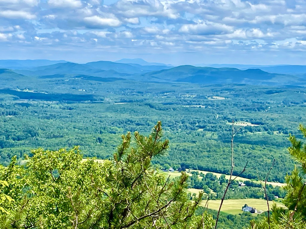
My next big challenge of the day was climbing Stratton Mountain to the Lookout. It was here, at the Lookout Tower in 1909, that James Taylor conceived of an idea of the “Long Trail“ extending from Massachusetts to Canada. Then in 1921, Benton MacKaye further extended the concept into a footpath linking scenic ridges of the entire Appalachian range – and the Appalachian Trail was born. A portion of the AT is the LT. Much like the PCT uses the John Muir Trail JMT as it extends from Mexico to Canada.

Stratton Mountain Lookout

The Stratton Mountain Tower was functional so I decided to drop my pack and climb to the top. The views were spectacular even with the smoke from the Canadian Fires. The haze obscured the mountains but you could see a good distance. I was pretty close to loosing my lunch, as I climbed this tower. It was solid but my fear of heights is something I’m trying to overcome. Maybe not today! I made it to the top, shot a few pictures and a video, then headed back down the long staircase to solid ground.

Atop Stratton Mountain Tower

The last three miles to Stratton Pond seemed like twenty! The terrain was downhill for the most part but my legs and feet were done for the day. Sometimes you just run out of gas and those last miles seem like a hundred. I arrived at the Shelter, dropped my pack and scouted an area to place my tent. Ultra said I should stay in the shelter. There’s lots of room. The fact that my tent was still wet, it seemed like a reasonable option. I’ll give you the verdict tomorrow. Oh, and Chef, another hiker, informed us that he was planning to get up at midnight. This is going to be an interesting night, indeed. Please Lord, help me rest in a shelter with many.

Stratton Pond Shelter

Day 42-43: June 27-28, 2023 Zero Williamstown to Woodford Hollow Elevation+3711’/-3387’ 16.8 Miles/543.0; 1619.0

Willows Motel has the best breakfast on trail. Paul and his Dad are from India. They understand what hikers need, want and desire. So when Bear and I walked in, our mouths dropped. There was a fruit spread that you only find at the finest Easter Buffet. Berries of all kinds, peaches, nectarines with plums, dates, walnuts and almonds, all kinds of yogurt including plain Greek, my most favorite. There were muffins, breads, bagels and plenty of coffee and tea along with Coconut Water. Oh my, this is nirvana. I ate to my hearts content and had a second bowl of fruit.

Breakfast at Willows Motel

All the hikers I’ve been hanging with, Bear, Stealth and the sisters went back to the trail. Winter Boots flew home to Germany. I’m really going to miss hm. You do indeed, meet Gods’ best out here! I stayed behind and enjoyed my day off. I did pretty much nothing at all. It was exactly what my body needed. Even Norman expressed his pleasure of just hanging around. I booked a ride back to the trail for an early morning departure. And relaxed some more.

This is the Life

My ride arrived Wednesday morning at 0630 and I was back on the trail by 7am. Today is a big day. A new state of Vermont. All I have heard about this state is Vermud. How muddy can it really be? Ends up, like a pig pen! It has something to do with the clay-like soil that doesn’t allow water to absorb. It just clumps up and turns to a mud-like consistency. With all the rain we’ve had of late, it really enhanced the mud making substance. You have no idea what it’s like to walk miles in mud. All I can say is if I was 5 years old, it might be fun. But at 60-something, it’s not a good look!

My Shoes are Baby Blue Usually

As I’m making my way down this river of water and mud, I see what I think is a hawk flying fairly low. It lands in the forest to the left of me. I look up and it’s an owl. A big huge owl. He is gorgeous with his big yellow eyes and fluffy owl feathers. I was shocked that he was flying about in the morning. They are nocturnal, hence the reason I always hear them at night. He must’ve been getting ready to nest when I scooted by. What an amazing bird you are.

Big Gorgeous Owl

I made my way to a new shelter that is still under construction. There was a crew of women building the soon-to-be shelter and stacking a rock wall. They had all the hand tools needed to do the job. They work for Green Mountain Club and are employed seasonally. This Shelter is replacing an older one with a new privy and tent sites. It is hard labor and you can tell, these chicks are tough cookies. It’s been raining off and on for the past seven days and they don’t get to go into town for showers or laundry. Kudos girls! Thanks for the hard work.

The New Seth Warner Shelter

Today was one of those days that you just have to embrace the suck. After lunch, I ran into Uncle and Pyro. They had camped at the new shelter and stopped along the trail to dry their tent and sleeping bags out. Sure as the sun comes up daily, it started raining. I felt terrible for them. They packed their damp items up, put them inside their packs and were right behind me. I could tell that Pyro was running on empty and told her about the hotel down the road. It’s cheap and they will pick you up from the trail. She pondered the thought, as I continued northbound.

Team Ohioes

The rain came down for a good hour or two. It was rained hard enough that I put my tent inside my backpack instead of it’s normal spot, in the outside pocket. Poor Norman was soaked and he was ready to hide jump ship and land inside my pack with the tent. This rain is relentless. I had just dried out my stinky shoes to no avail! What’s the point? Mud and rain, and more mud and rain. Oh and trails filled with water and a ton of mud. Just want to make that clear!

Shark Tooth & Spinx

If that’s not bad enough, now I have a river crossing. I believe before it started raining, the rocks were above the river. But now, everything is submerged and the only two options are 1. Take your shoes off, or 2. Walk through the river with your shoes on. Guess what I did? Yep, walked on water! We’ll I didn’t actually walk on water because I am a mere mortal and not Jesus. I just walked into the river, shoes, sock and dirty girl gaiters. And you know what, the mud was temporarily washed off. That looks better, until the next mud bog.

Several River Crossings

By the end of the day, all I could think about was how in the world am I going to clean this mud and muck off me and my shoes? I need a hot shower, and a place to dry off. I headed to Woodford Hollow Trailhead and decide to call it a night.

The Water After Cleaning Socks & Gaiters

The best part about today is my wonderful hubby George called me and tells me my new shoes have arrived. And to make this even better, Natalya, aka Blue will bring them with her when she arrives on Saturday. You’ve got to be kidding? That is how my Lord works. He knew that I was going to need some cheering up today and he made a special delivery of a new pair of shoes, much needed shoes, to me on the trail! Originally REI stated that my shoes wouldn’t be delivered till Friday, two days after Natalya planned to leave. That is a darn right miracle in my eyes. Thank you Jesus for your help with this detail that only you could orchestrate.

Pizza at Catamount Hotel

As I was looking for a place to pitch my tent, Stops A Lot drives up. He calls out Hiker-Hiker and I answer to that. Wanna a ride to town? I’m picking up a couple of hikers, Uncle and Pyro and I have room for one more. I thought for about one split second and said, heck yes, I’d love to go to town. He escorted the three of us to his truck and drove to Catamount Motel. Looks like I will be having a proper shower, a bed to sleep in and a place to dry out. There you go again God. What an ending to what I thought was going to be a wet and rainy night. After eating pizza with the rest of the hiking community at the Motel, I headed back to my humble room. Now I’m all tucked in, me and Norman in a wonderful bed with four pillows. A most perfect ending. And they slept happily ever after…

Goodnight Norman
This is a stretch as I was not always upright today! But we know a God of grace, and he withholds nothing!

Day 41: June 26, 2023 Mount Greylock. Mark Noepel Shelter to Williamstown Elevation+3222’/-3712’ 15.4 Miles/526.2; 1602.2

The weather pattern has definitely changed. It was to be expected. It rained off and on last night. No torrential downpour like the night before, but rolling thunder and damp surroundings. Platforms are nice as it keeps the bottom of your tent off all the mud and muck. But you need to be careful standing on them. They are quite slippery when wet!

Morning Fog

I packed up all my possessions inside the tent, had my coffee and reluctantly, packaged up my wet tent last. Once again, I was the first to leave the Shelter, but the rest of the gang were right behind me. The morning stroll was wet, really wet. The trail is a river of rain water with rocks, and sometimes wet boards to walk atop.

Trail Covered in Glorious Rain

There was a climb to reach Mount Greylock, the tallest peak in Massachusetts at 3491’. I remember looking at it last week from atop Mt. Race with Roddie. He pointed it out to me and said that’s where I would be headed. It was a grey day, lots of fog and mist. Apropos for the name of the mountain, Greylock.

Notch Pond in Da’ Fog

The summit of Mount Greylock features the only subalpine environment in Massachusetts. Because of the high elevation and the westerly winds, there is a wide temperature range from winter to summer and from day to night. This summit is the centerpiece of the Mount Greylock State Reservation. Designated in 1898, Mount Greylock became the first state reservation in Massachusetts’ state forests and park system. Established on less than 400 acres, the Reservation has grown to nearly 12,000 acres.

A Beacon Standing for Peace A Brief Moment of Sunshine

In 1931 construction began on a 93’ Memorial to honor Massachusetts men and women who had died during the World War. The tower’s beacon, possibly the most powerful light in Massachusetts, was intended to shine each night, perpetually, to honor the memory of fallen heroes and to guide aviators in their lone night-time journeys over the treacherous mountain range. Except for a few weeks in spring and fall, when the light is dimmed to avoid confusing migrating birds, the beacon continues to shine each night as a memorial to casualties of all wars.

In the Dense Fog The Door to Climb the Tower

Being there was no view to see as the fog was quite dense, I opted to head to the Bascom Lodge to eat a proper breakfast. I am down to tiny morsels of food in my sack and only had dried cereal and coffee this morning. I need something warm to get me off this mountain. Lucky for me the lodge was open and I found a way in. They have a breakfast special, Scrambled Eggs, Bacon, Yogurt with Fresh Fruit, Coffee and homemade Blueberry Muffins. Yes, I’ll take it all. And I did. My appetite ceases to amaze me!

Bascom Lodge at Mount Greylock Built by the CCC in the 1930s

After ravishing all that incredible food, I hightailed it down the slippery slope to Williamstown. The route descended nearly 3300’ over five miles. The down part is hard but the extended milage made it much more reasonable. There were a few slippery spots as my shoes have lost much of their tread, which accounted for my butt hitting the ground a couple of times. Lucky I still have bottom cushion and just got a bit muddy. As I made it to somewhat level ground, the rain started falling. This is a matter of fact. We are getting a lot of rain these past days. Luckily, the road was in sight. A nice couple was driving by, saw this drowned rat and offered me a ride. Without hesitation, umbrella and stinky me, jumped in their car within a few seconds. They drove me the bonus 3 miles to the Willows Motel.

Willows Motel in Williamstown

As I checked in and heard the weather report of rain for the remainder of the week, I made the conscious decision to stay put and take a Zero. I haven’t had a Zero since I landed in Urgent Care some 30 days ago. I think I’m ready. Lucky for me, Paul the Owner had a room available and yes, I could stay two nights. Hallelujah I am taking a full day off. And honestly, Norman is relieved. This rain has been hard on him too.

Chillin’ Norman

Bear, The Germans – Stealth and Winter Boots with the Sisters, Sparks and Church Mouse (she rarely speaks) along with a couple of hikers I haven’t met, are all basking in the sun rays when they infrequently appear. My gear is hanging out, my shoes are being dried, my clothes washed by Paul and now it’s time to prop my feet up and relax. I just might take a nap.

Stealth and the Sisters Sparks & Church Mouse

Bear and I head next door to the Pizza/Greek Restaurant. Interesting combination but the place is packed for a Monday night. I decide to go Greek and get Lemon Rice Soup, Gyro with Beef & Lamb and a Greek Salad. It was incredibly delicious. The kids headed for Oriental Cuisine and booked an Uber. We are all back to our respective rooms before 8pm. Life of a hiker is early up and early to bed. I watch a little Ninja Warrior, training films for the next few weeks and promptly fall asleep before 9pm.

The Bear and Me
Matthew 11:28-30

Day 40: June 25, 2023 40 Days & 40 Nights Cookie Lady to Mark Noepel Shelter Elevation+3958’/-2943’ 17.1 Miles/510.8; 1587.1

Is there any significance to 40 days? In the Old Testament, when God destroyed the earth with water, He caused it to rain 40 days and 40 nights (Genesis 7:12). After Moses killed the Egyptian, he fled to Midian, where he spent 40 years in the desert tending flocks (Acts 7:30). Moses was on Mount Sinai for 40 days and 40 nights (Exodus 24:18). Moses interceded on Israel’s behalf for 40 days and 40 nights (Deuteronomy 9:18, 25). The Law specified a maximum number of lashes a man could receive for a crime, setting the limit at 40 (Deuteronomy 25:3). The Israelite spies took 40 days to spy out Canaan (Numbers 13:25). The Israelites wandered for 40 years (Deuteronomy 8:2-5). In the New Testament, Jesus was tempted for 40 days and 40 nights (Matthew 4:2). There were 40 days between Jesus’ resurrection and ascension (Acts 1:3).

Pink Lady’s on the Trail

For me, my first 40 days on the trail have been significant. I have learned so much about myself, but I’ve learned even more about who I am in Christ. It has been humbling, to say the least. I came out here believing I was prepared. I’d been working out, going to the gym, hiking and playing pickleball, but honestly I was not even close, to being prepared physically nor spiritually.

Beautiful Meadows of Massachusetts

God has revealed that this undertaking of my own doing, is truly his love for me, but also for the people I have met along the way. Each day I have been blessed by a random stranger, some kindness that is beyond measure, and somehow someway I have been able to show the love of Jesus to people who may not known Him. These past 40 days have opened my eyes, ears and heart to just how much love there is if we take the chance to notice one another. Today was a perfect example of our fathers love.

Cookie Lady’s Hanger

Last night was the most torrential downpour I have ever experienced. Granite, I was inside a tin building which, from what I’ve been told, amplifies the sound tenfold. Even with that being the case, the amount of rain that dropped from heaven above, was in biblical proportions. I could’ve been in my tent, floating down the trail somewhere but Jesus had a better place for me. Ruth, the Cookie Lady, offered this haven to protect me as well as four other random strangers, and of course Norman, shelter from the storm. And it stormed! Rolling thunder and lightening for hours. When Sid and I were at Woods Hole Hostel last year, it was quite like this but ever-so magnified.

Calm Before the Storm

Once I got back on trail, I had a few choices to make. Am I going to save my fuel for dinner and not have coffee in the morning or better yet, hope to find a fuel supply in town. As I was walking northbound approaching Cheshire, I met a couple hiking southbound. We chatted for a bit and I mention to them I was looking for an outfitter that might sell fuel. She says there’s one about three miles from trail. Hmm, that’s a lot of bonus miles that I really don’t want to do, but I’d give it thought. They continued on and so did I.

Diane’s Twist in Cheshire

About an hour later, I see the same gal riding up on a bicycle. She tells me that she was sharing with the lady from the ice cream shop, which I’ll be passing in five minutes, my dilemma regarding fuel. Ends up she knows Steve, the Outfitter and when I get to town, he’ll pick me up and drive me to his store, then drive me back to the trail. Why did this unknown woman go out of her way, to help me? Because she is one of Gods messenger’s and just wanted me to know how much I’m loved. That’s our sweet Jesus, and he never ceases to amaze me.

Oyster Mushrooms

A few minutes later these two trail runners wiz pass me. They stop and want to know what I’m doing, where I’m going, and how long have I stunk as bad as I do? We’ll, maybe not the last question but I’m sure they thought it. Ends up Sue is a Mushroom Connoisseur. She stops and starts filling her mosquito net with Oyster Mushrooms. Oh my, I have seen these all over the trail but had no idea I could eat them. Then I show her different shrooms I’ve taken pictures of and she identifies Good vs Fatal. I get my mosquito net out and now I have mushrooms to eat tonight. Thanks Sue and Sue’s friend.

Sue Harvesting Mushrooms

As I arrive at Noepel Shelter, I share with my German friends, Stealth and Winter Boots, the oyster mushrooms. They have olive oil and spices and before I know it, we are feasting on these beautiful and delicate oyster mushrooms. The bounty I have seem along the trail are now filling my hungry stomach. (And we all survived to eat more the following day.)

Fatal But Pretty Mushroom

The final amazing thing, which I didn’t document is, I pitched my tent on a platform. As I head north, there are fewer places to pitch your tent, and more wooden platforms. These are ideal for free-standing tents which is not what I have. My tent requires guidelines to pitch it and using my trekking poles to make it upright. The positive is that it’s very lightweight, around 20 ounces, but needs ground that I can drive my stakes into. These platforms are not ideal for non-freestanding tents but can be used. I was able to pitch my tent atop it last night. With the rain, it did quite well and the best part of a platform is it’s level. I slept wonderfully.

Pancake 🤣 Mushoom

As I finish off my 40 days and 40 nights on the Appalachian Trail, I am so grateful for the beautiful people I have met along the way. If you ever question human kindness and goodwill, come out on the trail. There is not a day that goes by that I am not blessed with the love and support of random strangers. This world we reside in is much more loving than you could ever imagine. My faith in humanity is greater than ever, if I just humbly myself and receive it. Thank you Jesus for showing your love through these unforgettable moments that you have given me in the past 40 days. How blessed I truly am, and what unforgettable people you have placed in my life. What a wonderful world you have created.

My First Tramily – Couch & Braveheart

Day 39: June 24, 2023 Upper Goose Pond to The Cookie Lady Home Elevation+2044’/-1527’ 12.8 Miles/493.7; 1563.5

What a night of sleep I had, until midnight. For some reason my mind thought it was time to get up. I tossed and turned, heard an owl hootie hooting, which I haven’t heard in awhile and fell back to sleep. At 5am I was up and started packing.

Great Horned Owl of New England

By 6am, I was ready to vacate my private space when the sky opened up and poured down liquid sunshine. And it never stopped! Hmm, so do I sit in my tent and pray that the rain stops? Or do I venture out for pancakes and coffee? Hard decision, but my belly won out. I put on my rain jacket, left my pack inside my ever so wet tent and walked up to the Cabin. There were a handful of hungry hikers all waiting for b bvtheir breakfast so I put my name in the cue. I had a cup of coffee and we all talked about the weather.

Trail Back to Appalachian Trail

After a bit, I received my fluffy pancakes with lots of butter and syrup. I don’t know what it is but pancakes just taste better when you’re camping. They were delightful and the coffee was good enough for a second cup. Eventually I needed to brave the storm and pack up my soggy tent. I headed back out to my wet world, pulled my pack from inside my tent and decided that Norman was going to ride inside the pack today. He’s a bit scared of the dark but he agreed it would be better than smelling like a wet dog!

Norman Protesting Face

I packed my tent into its storage bag, leaves, dirt, grossness and all, then ventured out. There’s a saying on the Appalachian Trail, “No Rain, No Pain, No Maine”. Well today was the fulfillment of the rain part of this equation. Like it or not, a big part of backpacking is enduring the ever-changing elements. And rain is never an overlooked part of the East Coast experience.

Ranch House Along the Trail

I had to backtrack my .5 miles to get me on the AT. Them bonus miles add up. Once on the northbound trail, I was embracing my underused umbrella. It is a vital piece of equipment that I bring and hope I never have to use it. It’s like insurance. Today, the insurance paid off. Everyone else were wearing ponchos, or rain jackets but I had my tank top on and a good umbrella. It keeps me relatively dry, but doesn’t do a whole lot of good for the outside of my pack. The inners are fine. Norman and all my gear is nicely tucked away inside a trash compactor bag, and that thing is impermeable to rain! It’s bomb proof.

Uncle & Pyro

The plan was to make it somewhere where the sun was shining and I could dry out my tent. Not looking so good. I made it over the one and only climb of the day and after that, it was trying to avoid major puddles, swollen creeks and slippery rocks and leaves. Those leaves are my biggest nuisance. By noon, I made it to October Mountain Shelter. And the rain had not ceased.

Sparks & Winter Boots

The Shelter was the only reprieve I have had all morning from the rain. When I arrived, the kids from Germany and US were sprawled out. I placed my soaking wet pack inside the shelter, pulled out my lunch and proceeded to dry out. Once again, the talk was where are we headed towards tonight? There’s another Shelter 9.5 miles north, there’s a town 12 miles north that has a hotel and then there’s camping in the woods. The other backup plan is to stop by The Cookie Lady’s place and make a decision.

October mountain Shelter Luncheon

I took off once Uncle and Pyro showed up. I wanted to give them space in our very crowded shelter. The trail was engorged with water by early afternoon. There was no point even trying to keep my shoes dry, so I just started walking through the mud and muck. Before long, the kids passed me up as they were all headed to the Cookie Lady’s place. Save some cookies for me, I pleaded.

Cookie Lady’s Porch

Once I arrived, I understood why this was the talk of the trail. Ruth, the Cookie Lady took over where Mrs. Wiley left off. Mrs. Riley ran this place for nearly 30-40 years, baking cookies for hikers and growing blueberries. She has been a status symbol of all that is good regarding the AT. When her husband passed, her daughters knew Mom could not continue and decided to sell the place. That’s when Ruth came in. Long story short, Ruth is much like Mrs. Riley. They both have degrees in nutrition, love to sew, grow vegetables, and berries and have a heart for hikers. I think I will stay!

Cookie Lady & Michael’s Home

Ruth shows us around, explains the history of the place, gives us a mason jar full of hibiscus tea and a wooden box of homemade cookies. This place is getting better by the minute. We are escorted to the Hanger, an airplane hanger that Mr. Wiley used for his plane, which is now converted with foam mattresses. I’m thinking this is my home for the night.

Homemade Cookies for Hikers

I proceed to unload my pack, which everything is thoroughly soaked in water, and hang it from any spot imaginable. As I’m drying stuff out, I notice a Tail-Dragger Plane overhead. He’s pretty low, and before I know it, he is landing on the strip of grass to the east of me. This is wild. Maybe he’s the owner, the husband?? Before I know it, Ruth, the kids and the husband are outside questioning the pilot. Ends up he read somewhere that this is a landing strip and evidently he randomly lands on unauthorized runways. Ruth is scratching her head as this has never happened before. They bid the pilot farewell and hope that this is a one and done kind of thing! Crazy happenings on the AT indeed.

Unexpected Airplane Landing

After all the excitement is done, I head back to the porch with Ruth and the hikers. Ruth makes us an amazing chili, rice with vegetables dish that was hearty for this rainy day. I couldn’t have planned this better. The sun comes out, my gear is dryer, I have a proper bed to sleep upon, and my shoes, well I can’t have everything. They are still wet, but that’ll keep me humble. It was another incredible day on this magic strip of wet, soggy dirt, that leads me to Maine.

Old Barn Near Runway

Day 38: June 23, 2023 Shakers CS to Upper Goose Pond Elevation+2060’/-1455’ 10.0 Miles/482.9; 1552.8

Slept pretty good in my tent. But Norman started snoring and I was ready to kick him out. I think he’s congested. There’s a lot of things blooming and his allergies must be causing him issues. I take Benedryl to help me sleep, and maybe that’s why I have no sneezing or hay fever. But this poor guy, rides around exposed to all the elements daily and never gets a chance to hang from a tree.

Me and Norman

The campsite was a flurry of activity this morning. There are some early risers in this bunch. Most of us were packed up and hitting the trail by 6am, including me. All I can think about is getting to Goose Pond and relaxing the afternoon away. No big miles, just an easy peasy kind of day.

Morning Stroll Through Bear Country

I was on high alert looking for Mama Bear. I saw a big pile of fresh bear scat but no signs of Mama or her cubs. She’s probably heard that Norman is riding shotgun and is hiding out. I guess that monkey is good for something. I shouldn’t put him down so much because in reality, he’s the only partner I’ve had who is still with me. He doesn’t complain, doesn’t eat much and only snores a bit. Or maybe that was me snoring and I blamed it on Norman. He’s a good companion, snorer or not.

Tyringham Cobble, A Hill High Over the Town of Tyringham.

After my little break, I was ready to get this show on the road. There were quite a few boardwalks today. Some were better than others. The one thing I can say about Massachusetts is it’s about the flattest hiking I have done. There are a few climbs but then there’s a lot more roly poly hills. It makes for easygoing days along the trail.

Hop Brook & Pastures

I hiked with Poncho and Strawberry Shortcake for a bit today. We stopped at the infamous Trail Stand. It’s more like a small shed. I opened it up, and inside is a retro-looking refrigerator packed full of soda and ice cream. Hmm, breakfast? Sounds good to me so I had a Ginger Ale with Strawberry-Lemonade and an Ice Cream Sandwich. It hit the spot. Much better than any kind of oatmeal. On top of that, they had Wi-Fi so I was able to publish my blog. I tell you, this AT is where it’s at. If you are lacking something, it’s your own fault because everyone wants to help you out. The girls and I sat, had our breakfast and got back to hiking.

Trail Stand Stocked With Sodas & Goodies

The rest of the morning was mostly in the green tunnel. Lots of forests, trees and ferns. I scared a couple of White-Tailed Deers. Those deer are much bigger than our Black-Tailed Mule Deers. At least twice the meat on them. Good eating indeed.

White-Tailed Deer & Bambi

I made it to the junction of Goose Pond. The girls continued on towards another pond about four miles north. There was a dog that was following Poncho because she fed it. He was a bit scared and a lot hungry. He had a collar and obviously was someone’s dog but the someone was nowhere around. The dog continued north with Poncho and I headed to Goose Pond.

Strawberry Shortcake & Poncho With Robbie the Lost Dog

Within five minutes or so, I met Maggie, the Caretaker of Goose Pond Cabin. She was looking for the dog. I told her where I saw him and she was grateful. She had a pocket full of cheese and a leach so the dog would be reunited with his owner. Good news for all concerned.

Goose Cabin & Bunks

I made it to Goose Pond Cabin, found a place to pitch my tent and headed to the beach. As far as I can tell, it’s a lake! The body of water is huge. It even has an island in the center and a canal that connects Upper Goose Pond to Lower Goose Pond. There are Pontoon Boats, Kayaks and Canoes and a SUP being skippered by a gal. It’s a very serene lake or pond, whatever you want to call it.

My Dirty Filthy Feet on Goose Pond Dock

Today is a chill axing kind of day. I arrived around lunch and have no intentions of leaving till tomorrow morning. The best part is they serve free Pancakes and Coffee in the morning. What a deal. I hung out on the dock and talked with the locals, played with their dog and ate their potato chips. Well they offered them to me and it would’ve been rude to turn them down.

More Mushrooms – Lions Mane?

The rain has arrived and I’m back in my tent. It’s a perfect day to relax in my tent and be sheltered from the rain. I think I’ll take a nap. So glad I’m not waking in this. Perfect day to take a Nero, and an afternoon off.

Day 37: June 22, 2023 Great Barrington to Shakers CS Elevation+3735’/-1954’ 17.6 Miles/472.9; 1542.8

Oh glorious sleep. I think it has to do with a couple of factors. I was exhausted yesterday. When I entered my room, I turned on Family Channel – Hallmark and promptly fell asleep. Such riveting stories but I already knew the ending. I slept way past my wake-up time.

Lots of Cemetery’s Along the Trail

I was pretty much already packed, had a ride lined up and was back on the trail before 8am. Not bad for a town stop. The morning walk went through some pasturelands, and had a couple of rocky climbs that overlooked the Housatonic River and valleys below.

Farmlands and Pastures

Once I crossed the highway, I saw Gasket. He looked like I felt last night, exhausted. Gasket was ready to head back to Town, and get a room for the night. I totally knows how he feels. Some days I am full of energy and tearing to go, and other days I am spent by noon. The incredible sleep I had last night, kept me moving.

Benedict Pond

I had a little climb up to Benedict Pond. This is a local hangout for the neighboring area. It is a good sized pond, more like a lake with boulders and frogs croaking. I met a nice couple from South Point, England, Caroline and Ian. They were visiting cousins nearby and went for a stroll to the lake. Caroline had lots of questions regarding my excursion. We talked for a bit about trail life, what in the world do I eat out here, and if I’m afraid? These are the typical concerns that most people have. I showed them my lunch, salami, cheese and a big dill pickle. Ian wanted to know where the bread was? I thought to myself, I do need to find some good artisan bread.

New Friends from England

I retrieved my snack bag and they went to find groceries. The pond was pretty, the day was nice and I ate my lunch. There were dragonfly’s all over the pond, and butterflies landing on the rock beside me. The bullfrog was out of sight but you could definitely hear him over the birds. He was croaking like he had something to croak about!

Biggest Fear – What Mushroom Shall I Eat

After lunch, I started my afternoon push to camp. I wanted to get a few more miles in so I set my goal for Shaker Campsite. In Massachusetts, they have required areas to camp at. There are Shelters, which I’m not a big fan of, and primitive camping with Bear Boxes and Privy’s. This site even has platforms to put your tent on top. I haven’t tried that yet, so we’ll see.

Interesting Water Source – I Passed

Around 6pm, I arrived in camp. There were quite of few people already set up. Both platforms were used, and most the sites were spoken for. A hiker told me about a site above the picnic table. Perfect, I’ll head over yonder. It was just what I needed. I built my home and went to get water.

Beavers Busy at Work

I met Poncho and Strawberry-Shortcake. They are flip-flippers like me and started just a couple of days before I did. And they are females. I haven’t seen many women out here since C2T and Braveheart left. Poncho pointed me to the creek and we talked a bit later.

Stone Wall From Yesteryear

Shaker Campsite has quite a bit of history. 1762, the Shakers came to this area and lived in communal homes. They grew in numbers and by the 1800’s, there were close to 100 Shakers. They were farmers, tapped close to 5000 trees and produced Maple Syrup. They built a 5-Story building for growing, packaging and selling seeds. In fact the rock wall that still stands was most likely a small barn. My tent is sitting on top of it. Sadly, the Shakers slowly left to other places, and by 1858, the last of the community members had sold their properties and moved elsewhere. It seems that they were an important part of this rich history and their memory is still alive.

Shaker Campsite

I made my dinner, Backpacking Pantry’s Chicken Pad Thai. This is my most favorite version of this meal. It even comes with peanut butter packet and fresh peanuts. I was only missing bean sprouts. I probably could find some in all the ponds I had passed by today. Next time.

Bean Sprouts – Maybe Algae

Well that wraps up another day on the Appalachian Trail for me. It’s nice to be sleeping near others, knowing if Mrs. Bear comes, I’ll have some backup. From reading my FarOut App, there’s a Mama Bear with two cubs in the area. I’ll keep an eye out and let you know if I see or hear them. For now, I’m signing off.

Beautiful Morning Sunrise

Day 36: June 21, 2023 Summer Solstice Sages Ravine CS to Great Barrington Elevation+2453’/-3725’ 15.3 Miles/455.3; 1525.1

When I arrived at camp last night, I was exhausted. The climb and miles kicked my booty. So I made haste with getting my tent set up, ate and crawled into my bag. And then it rained. I have to say that I am getting pretty good at setting up this tent of mine. The fact that it rained for close to an hour, yet I was nice, dry and warm inside my little place called paradise!

Sages Ravine Tributary

Around 11pm, I heard a scratchy at the side of my tent. It wasn’t a bear, and it wasn’t a mouse. The two intruders I would’ve expected. It was a raccoon. That little bandit wanted inside with me. I remember Mooch telling me about the raccoon that he had to fend off when it tried grabbing his food bag and taking off with it! I was having no part of that. I asked the little Bandit that she is, go away. I guess she didn’t hear me so I had to tell her again with a big swat at my tent and then, she understood. She left and I heard no more of her scratching.

Little Miss Bandit

Before the birds started squawking, I was up. I really want to get to town and get my food bag. I’m down to oatmeal with dried bananas, yuck, some coffee and two dehydrated dinners. I have one beef stick for lunch and a handful of jelly belly’s. That’s good planning on my part. I packed up my wet tent and was on trail before 6am.

Morning Stroll Along the River

The morning walk was glorious. No one but me and the Lord this morning. I didn’t even need to slay spider webs. I guess they don’t spin their countless webs when it rains. That was a pleasant surprise.

Beautiful Lush Garden of Eden

The saddest part of today is I’m leaving my most favorite state of all, Connecticut. I crossed over Sages Ravine Brook, and there was the sign. Welcome to Massachusetts. I considered turning around and just hiking back and forth in Connecticut, like a yo-yo. But that would never serve me and I’d never reach Katahdin. So I reluctantly moved north and entered new territory.

Bummer…Oh How I Long for CT

The first few steps were lined with ferns and seemed much like my favorite place. But that all changed very quickly. The blaze sent me to the left and up a rocky path towards Mt. Race. As I was climbing up the ledges, I could hear someone approaching from behind. Imagine that, a fellow hiker caught up with me.

Roddy, Local Teacher & Hiker

Roddy, aka Roderick is a local. He likes backpacking and comes out as often as he can. He was doing a section and just so happened to camp at the same place as I did. Roddy knows the area but hasn’t hiked the north end of Mt. Race and Everett. Lucky for me, he knows where the best overlooks are located. He escorted me along the ledges, pointing out certain peaks, and sharing his knowledge of the plants, trees and flora along the way.

View from Southern Ledge Mount Race

We reached the south end of the open ridge on Mount Race. For the next half a mile, there were spectacular views to the east, south, and north from the peak. On a clear day which we had today, we could see Mount Greylock to the north, which is located at the far northern end of this state. It was stunning!

In the Distance is Mount Greylock

The next grueling climb was Mount Everett. Yesterday I wrote that Mt Race and Everett were a ski area. I was so wrong. Sorry about that if you already started planning your next ski getaway. These are mountains with ledges. And there’s no skiing, just hiking. Both are less than 3000’ tall but seem much bigger.

View from North End of Mount Everett

Once atop Mt. Everett, we stopped for some snacks. I could’ve eaten a side of beef, but settled for a handful of nuts. There were four cement footings that Roddy said used to be a fire lookout tower. It would’ve been one incredible place to view the surrounding landscape.

Foundation of the Old Fire Tower

The downhill was the typical. One scary step after another, with an occasional butt slide because my legs are quite long enough to take the next giant leap. Before long, I was back on level ground with dirt, not rocks, under foot.

Guilder Pond – Drinking Water

Roddy made it down and was waiting for his ride. A Trail Angel “Father Time” was parked on the roadway. He had sodas, apples and every type of junk food a stinky hiker would devour. After drinking an iced cold tea, Fritos and an apple, I was quite content. Ends up that Father Time is friends with Out & Back and Chance. He came earlier and took them into town for breakfast. After talking for a bit, I asked the question? Any chance you can give me a ride to Great Barrington? Father Time was happy to help and before I knew it, I was checking into Quality Inn. Roddy had already lined up a ride back to his car so we said goodbye. What a great hiking partner he was today.

Roddy and I Atop the Most Northern Ledge of Mount Everett

Great Barrington is a nice little town. The hotel is situated right on Main Street, a few blocks from the Post Office. I offloaded my pack, took a shower and put on my somewhat clean Town Dress. Lucky for me the Post Office has normal hours and I picked up my resupply box. I emptied the priority box, then loaded my daypack with my next weeks food. After all that, I proceeded to find real food. There was a great outdoor Mexican Restaurant which fit the bill. I ordered Chicken Tortilla Soup with Avocado and a Beer. And of course, chips and salsa. Perfect combination.

After my early dinner, I headed to the city park where they had live music on Wednesdays. Yeah for me. I saw an older gentleman sitting on a park bench and sat down with him. Ben is a local and he likes coming down to the park. He asks me if I’m from around here and tell him I’m hiking the AT. He’s fascinated and tells me about the one time he backpacked in Nepal. We have that in common. Great starter.

Town Hall Park & Music

After about an hour of riveting conversation and sharing our faith in Jesus, I decided it was time to head back to my home for the night. I have chores to do like laundry, restocking my food bag, and getting some much needed rest. Hopefully I won’t have any critters trying to get into my room tonight. I’m going to have Norman stand guard. It’s time that he starts pulling his fair share.

New Friend & Hippy Ben

Day 35: June 20, 2023 Cornwall Bridge to Sages Ravine CS Elevation+3312’/-2421’ 19.4 Miles/455.3; 1510.6

What a stupendous night of sleep. I woke up and was ready to hit the trail running. Honestly I’d like to get some big miles in the next couple of days so I can be in Great Barrington for my resupply by Thursday. My food bag is fairly low and I’m hungry all the time.

This Wall Was Built in 1800 as a Way to Transport Water – Aqueduct

The first few miles were quick and before long I made it to Falls Village. It’s a quaint town with great cafes. The Village Cafe was open for business and every hiker on trail was there. I ran into Dice, Uncle Sam & Legs, and my favorite couple of the trail, Not A Chance and Out & Back. We all had the same idea, fill our belly’s with good nourishment.

Oh, That Ain’t No Egg McMuffin

After eating my Egg Sandwich, I headed out with much to do. I wanted to get a few extra miles in. Falls Village evidently gets its name due to the beautiful waterfalls. Once again, I am clueless as as to what is up and coming, so I was blown away by the cascading water next to the trail. I dropped my pack and hiked down to the bottom of the falls. It’s is absolutely breathtaking. I took some photos and headed back up to the trail where my pack and Norman were waiting.

Falls Village

There was a hefty climb but in Connecticut fashion, it was well thought out. The trail had switchbacks and steep but not too steep. I met a new hiker who was taking a break at the top. His name is Base Clarinet Man or BCM. He’s a section hiker who comes out every year and hikes for 2-3 weeks. His wife is supporting him and he walks about 6-10 miles a day. We had great conversation and he’s a Southern Baptist. As we parted ways, he said, “May the Lord bless you on your hike and May He bless you in your life.” What a profound message and blessing. Thank you Brother BCM.

My Evangelist BCM

Just before tackling my final climb of the day, I sat and had lunch with Chance and Out & Back. We talked about careers and life outside the trail. They both are in their 30’s and honestly work so they can support their backpacking adventures. No commitments or obligations, no mortgages or car payments, just living for the next trail. Chance has hiked the PCT like five times! She works in Death Valley and is an incredible person. She only has a few more days on the trail before she goes back to work and Out & Back will finish the AT on his own. Such a life these two live.

Check Out The Proper OSHA Staircase

Once I finished my tuna, crackers and cheese, I went back to work, climbing the next mountain. Bear Mountain. I think every state has a Bear Mountain. There must be parameters to name it such because they are always a good butt kicking kind of climb. This one was no different.

The Giant Stone Thumb

The first obstacle was getting over Lions Head. It’s a fairly steep rock face that affords fantastic views southeast into the town of Salisbury, with Wetauwanchu Mountain behind it. This was the toughest climb I’ve had since entering Connecticut. Once atop, the trail flattened out for a bit.

On Top of Bear Mountain with Chance and Out & Back

The final push was getting over Bear Mountain. It wasn’t too terribly difficult until I was at the base of the rock pike. Hmm, I have to admit that I considered bypassing the final hurdle being it really isn’t part of the official trail. But then I’d miss out on the 360 degree view from the top.

Incredible Views of Twin Lakes and Hills to Climb

Bear Mountain is the highest peak in Connecticut with a rocky summit. It’s actually a giant cairn (described as a tower, but it’s really just a pile of rocks with a flat top). The views span the valley of Twin Lakes to the east, to the Taconic Range to the north, with a particularly good view of the south slopes of Mounts Race and Everett, the local Ski Area. It was well worth the extra effort.

Coming Down Bear Mountain

My final exercise for the day was getting off Bear Mountain before the impending weather came in. This was the steepest downhill in this fine state. I ever-so-carefully hiked down, and finally made it to camp after 6pm. It was an exhausting day but a worthwhile day of hiking. The rain held out while I pitched my tent and made Vegetable Curry & Rice. As soon as I was ready to crawl into my little safe place for the night, the rain arrived. Thank you Lord for waiting. That was your most perfect timing.

Incredible & Lush Fern Grotto
Oh How Blessed We Are to Have an Unmovable, Unshakable God

Day 34: June 19, 2023 Housatonic River to Cornwall Bridge Elevation+3464’/-3731’ 17.4 Miles/435.9; 1482.4

I love tenting by a flowing water source. It soothing and lulls me to sleep. It was later than usual when I looked out my tent. The sun had already rised and I was amazed that I slept through the bird song. Yeah for me. I packed up my possessions and headed down the trail.

Big Bear Waking Me Up – No, Not Really

Within a mile or so, Bill drove by. Bill is a Volunteer who has claimed a piece of the trail that he is accountable to maintain. “Do you need a ride? I’d love a ride. I was hoping to get to a motel today to get my body and clothes cleaned. It’s been way too long. I always feel bad when I get in a car with a random stranger. Sorry I stink so bad. Bill had his window down and I did the same.

Local Cemetery Along The AT

Before I knew it, I was at the Hitching Post Motel. Jack checked me in and already had a room ready. Bless your heart Jack! He did my laundry and I took a shower. My hair is matted like the beginning of dreadlocks. Yuck, it’s not a good look. No conditioner so my flimsy comb was going to work overtime. Luckily I have very thick hair so when my comb attempts to do what it’s suppose to do, there’s a lot of stray hair that comes out of my head.

Bill & Clean Hair Day 😊

Bill, my original morning ride, returns after I’ve bathed and took me back to the trail. But now, I can hike in my Town Dress, and walk without my backpack! Before I knew it, I was on the trail again. Slackpacking is such a luxury. My daypack weighs maybe 3-4 pounds compared to my everyday backpack that is 20-25 pounds. I could do this walking on my hands. Well maybe not.

Beautifully Placed Rocks of Connecticut

Once I was dropped off, there was a climb. Bill asked me to report back of any needed maintenance that was required. Honestly, the only thing I saw was a few grasses that encroached towards the ribbon of dirt. No trees down, no blowdowns, everything was in its place. I love Connecticut.

Caleb’s Peak Overlooking Rolling Hills of Cornwall

I made it to Caleb’s Peak, Bill’s section of the trail that he inherited. The sign was clear and no moss was growing on it. He told me that he’d hike up there and would bring a brush to make sure the sign was clear of any dirt, debris or grub that would distract from its beauty. I never gave that thought till he shared this with me. Such pride that he has in his stretch of trail.

The Ledges

I headed off the ledge and started down to the water source. Cali-Roll shows up. I met him back at Unionville weeks ago. He’s also a flip-flopper. Cali-Roll hiked with me the rest of the day. So why Cali-Roll?

Cali-Roll

This is such a great story. He’s Japanese-American. Someone thought he should be named after the Avocado Sushi Roll named the California Roll. I shared with him the fact that my Mom was the inventor of this roll. Seriously? Yep, while she would eat sushi in Pasadena back in the 70’s, she asked the Sashimi Chef if he would add avocado to her roll? He told her if she would bring the avocado to his Sushi Bar, he’d name the roll after her. Hence the name, California Roll.

We had a great time hiking together, sharing our faith and what we were doing out here. Cali-Roll just graduated college and said he always did things half-way. He wanted to do something different and was ready to prove to himself that he was better than half-good. What a thought, a revelation to consider. We hiked for hours, sharing tails of the trail and similar friends we have met.

On St. James Ledge

Cali-Roll ended his day at the Stewart Hollow Shelter and I continued to Cornwall. The trail was the flattest on the AT. As I ended, Bruce was checking on his sheep and cattle. His wife inherited a ranch that has been passed down for generations. He loves working the farm, and his son-in-law helps quite a bit. Bruce is a very content man. Would you like a ride to town? Heck yeah, and off I went in his work cart. With the wind in my face, I was thrilled to be riding, and not road walking. I think I have finally found Mayberry RFD!

Bruce, The Happiest Man in Cornwall

Before long, I was back at the Hitching Post Motel. I’m eating dehydrated Chicken Fettuccine and drinking tea. Another incredible day. My feet are sore, my legs are hurting but I am sleeping in a bed tonight. And I can take another shower! Life is good.

AT Along the Housatonic River